6 Hikes for Stunning Spring Sightings in Spokane Valley & Surrounding Areas
Posted on March 28, 2022 at 6:00 am
By Caitlin Wheeler
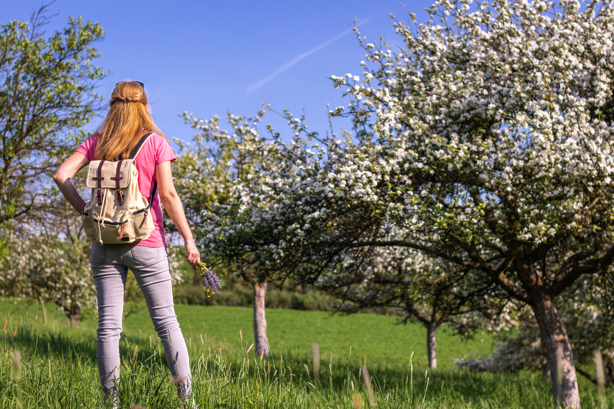
I love cherry trees. Specifically, I love them for the two or three days in spring just past their brightest bloom, when you can stand underneath one, tug on a branch, and find yourself absolutely showered in the falling blossoms.
In the spring of 2020, there wasn’t much recreation I could do in my little apartment, and I wasn’t traveling very far outside of it because the whole world still wasn’t sure how the virus spread. But one thing I could take some comfort in was taking walks near my home.
I try to make it out to a good cherry tree on the exact right day every year. The blossoming trees at Mirabeau Park in 2020 have been the most memorable of my life. Amidst the fear and uncertainty, they were one tiny, immediate experience of joy, of good anticipation fulfilled to the fullest of my expectation. The image of my dog’s soft fur waving gently in the wind and pink petals all bespeckled throughout is seared deeply in my mind’s eye.
I don’t love the cold and wet weather that February and March so often bring, but I have a sharp eye for the little yellow, purple, and green buds signaling that cherry blossoms are on their way.
Here I share a few of my favorite places in Spokane Valley and the eastern part of the county to seek out for those early spring revelations.
And if you are looking to explore other spots around the county, check out my recommendations for North Spokane, the West Plains, and south of Spokane. You’ll also find some safety tips in my previous blog about hikes and walks in South Spokane County.
Hikes in Eastern Spokane County
Note: Travel times are an estimate and indicate travel by motor vehicle.
Dishman Hills Natural Area (Sargent Entrance)
This trail is close to the following libraries: Spokane Valley (10 minutes); Argonne, The BookEnd, and Moran Prairie (15 minutes); Otis Orchards and Airway Heights (20 minutes); and North Spokane, Medical Lake, Cheney, and Fairfield (30 minutes).
I scan every spot of forested land for adventure potential. Often, the forested areas alongside roads aren’t actually accessible to the public. But with a parking lot located directly off of Appleway Boulevard, Dishman Hills Natural Area is one of those rare swathes of forest that will catch your eye and invite you to explore.
The Dishman Hills Natural Area boasts a variety of short loop trails of medium difficulty, ranging from about a mile to over 4 miles, with lots of detours in between. This is also one of the most varied natural areas in Spokane County, with steep basalt hills, piney forest floors, a small but satisfying vista at Eagle Peak, and a froggy docked pond.
I especially like to visit in March, when I can hunt out the early springtime omens of buttercups, grass willows, and serviceberry. These flowers are especially lovely in contrast to the lush gorges that mark this territory. But keep a map on you because some of these trails can cause you to get lost pretty easily.

Tips & technicalities
Parking is free. Leashed dogs are welcome. Trails are not wheelchair accessible. However, if you drive past the first parking lot, you’ll find Camp Caro (and its parking lot)—a small wheelchair-accessible park nestled in the woods. Camp Caro also features restrooms, a playground, and a reservable lodge. Dishman Hills Conservancy often offers free activities for a wide variety of ages and abilities, as well as many self-guided educational resources.

Suggested reading
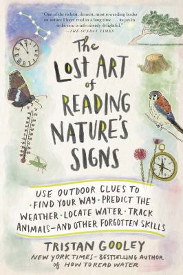
The Lost Art of Reading Nature’s Signs, by Tristan Gooley
There is little I love more than listening to an expert share practical knowledge and fun facts about the subject they know most about. This book is the epitome of that kind of fact-sharing.
Dubbed by the BBC as “the Sherlock Holmes of nature,” Tristan Gooley uses this book to share the wealth of knowledge he has gathered in the 20+ years he’s spent navigating the outdoors.
Learn why, how, and when ivy seeks out shade so that you can use it to find north. Discover calm water by noticing rainbows that form more than half a circle—meaning that the sun’s rays must be bouncing off a smooth surface to create an antisolar point above the horizon. Memorize a few easy methods to identify what messages birds are conveying to each other—without having to memorize each individual bird’s songs.
Full of interesting material and written in an engaging manner, this book a much quicker read than its 400 pages may imply.
This trail is near the following libraries: Spokane Valley, The BookEnd, and Argonne (10 minutes); Otis Orchards (15 minutes); Moran Prairie (20 minutes); Cheney, Medical Lake, Airway Heights, and North Spokane (30 minutes).
With its wide-open fields, it’s no surprise that Mirabeau Point Park hosts the annual Valleyfest, a weekly summer Spokane Valley Farmers Market, and many other seasonal outdoor events. And Mirabeau’s extensive grounds also make it a great spot to visit outside of event hours.
Seek out solitude via one of the several short paths that traverse the woods behind the park lawn. Though they do climb a small hill, these paths are traversable by most casual walkers. In springtime, you’ll find the cliff blanketed in arrowleaf balsamroot. Keep your eye out for the many skittish rabbits that inhabit these trails!
Tips & technicalities
Parking is free. Leashed dogs and cyclists are welcome. Some trails are wheelchair accessible, particularly the Centennial Trail, which offers its flattest and most leisurely stretches throughout the Valley. Restrooms and playgrounds are available at Mirabeau Meadows.
Suggested reading
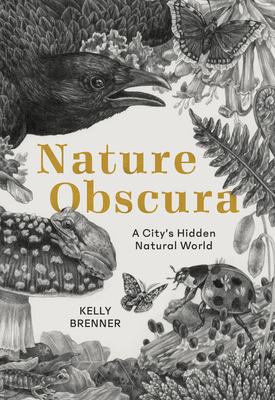
Nature Obscura, by Kelly Brenner
I loved this book for how closely the author’s desires matched my own. A native of Seattle, Kelly Brenner set out to comprehend the nature just outside her own front door.
Brenner digs through algae to examine the invertebrates that live nearby, studies the history of the muskrats who burrow under Seattle homes, and maps out the size of fungal networks 1,500 acres across. While much of her time is spent in parks, she also often stops to consider her own back yard and even the spiders in her basement and the fungus that forms spores on her old bread.
Nature Obscura offers the reader a sense of appreciation for non-human city life. This book motivates you to seek out urban trails, like the Sullivan Park Trailhead on the Centennial Trail that takes you from the Spokane Valley Mall right to Mirabeau Point Park.
This trail is near the following libraries: Otis Orchards (15 minutes); The BookEnd and Spokane Valley (20 minutes); and Moran Prairie (30 minutes).
Post Falls Community Forest is across the state border, but it’s no further from Spokane Valley residents than downtown Spokane itself—hence, its inclusion.
Trails range from easy to strenuous, with wetlands and scenic ravines in one direction and a roaring waterfall in the other. It’s not uncommon to find osprey or bald eagles hunting the river here.
In April, you’ll find the ground littered with grass widows and avalanche lilies. Trails are marked with colorful dots at each crossroad to help you navigate, but I advise you to keep your phone on you for navigation because these forested paths can quickly get confusing. You can make a day of it by picnicking at the beach at Q’emiln Park (pronounced “ka-mee-lin”), just a few hundred feet away.
Tips & technicalities
The forest offers limited free parking at Riverview Drive. Parking at Q’emiln Park requires a parking pass at $5 day or $30 for the season from Memorial Day to Labor Day. Leashed dogs are welcome on the forest trails, but Q’emiln Park has a no dog policy. Paths are available for equestrians, bikers, and snowshoers. Restrooms are available.
Suggested reading
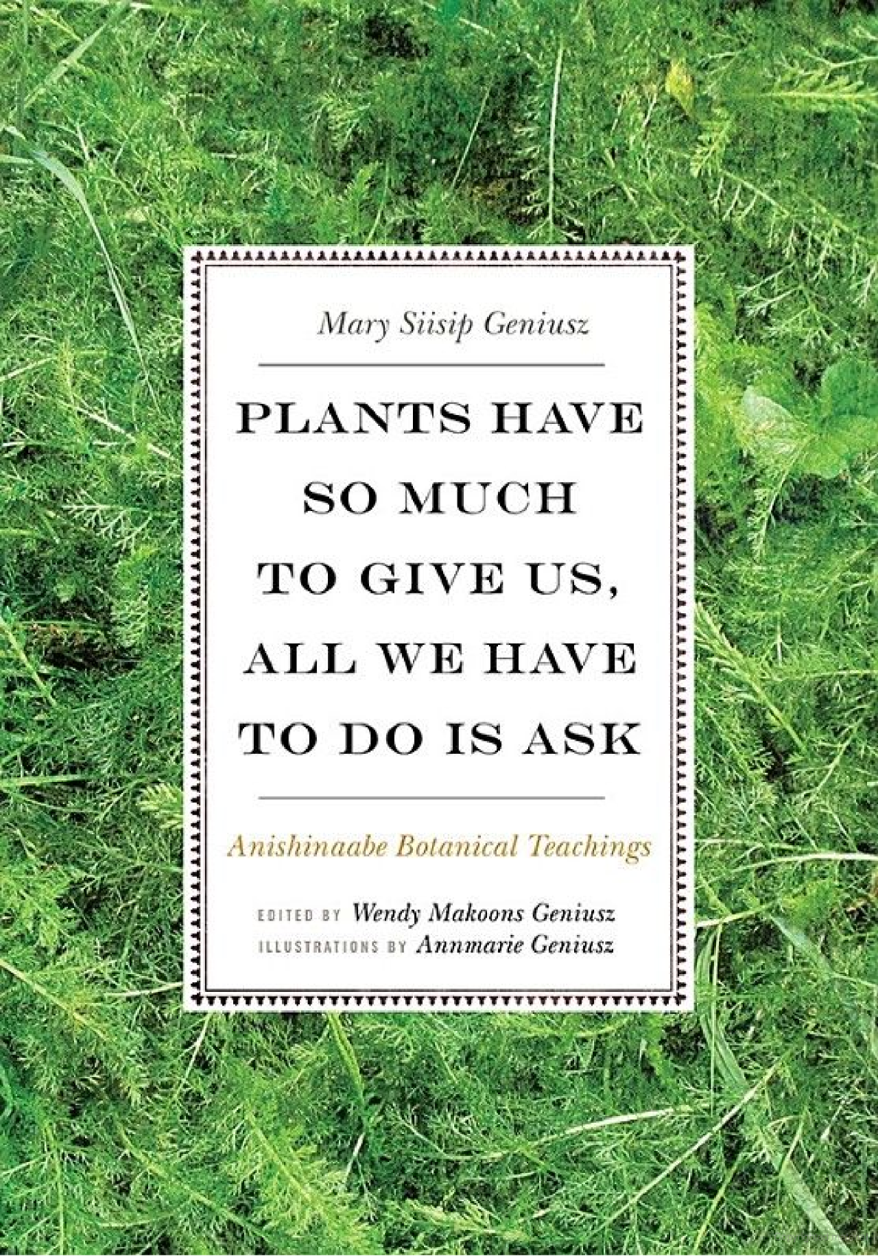
Plants Have So Much to Give Us, All We Have to Do Is Ask, by Mary Siisip Geniusz
In this book, Geniusz shares the wisdom of her teacher Keewaydinoquay, an Anishinaabe-mashkikiiwikwe (Anishinaabe medicine woman) and ethnobotanist.
Rather than a dry account of plant uses, this book can be read as one step toward revitalization of Anishinaabe knowledge. The Annishinaabe treat plants as beings in their own right, with their own “histories, stories, beliefs, and ways of life.”
Plants Have So Much to Give is a great read for anyone who wants a deeper understanding of the Anishinaabe people as well as for those interested in non-European ways of knowing. If you’ve ever felt a disconnect between reading a foraging book and actually being out among the plants, this book might just offer the approach you are looking for.
This trail is near the following libraries: Otis Orchards (15 minutes), Spokane Valley and The BookEnd (20 minutes); and Argonne (25 minutes).
Liberty Lake Regional Park offers something for most ability levels. The lake and park area offer areas for swimming and picnicking, play equipment, barbecues, and larger event spaces. There is a campground with cabins and spaces for tents and campers, where you can fall asleep to the sound of frogs calling out in the marsh.
And of course, there is the trail itself, which tracks through the wetlands before climbing up over streams and through cedar groves into the sub-alpine hills.
As a moderate hiker with an aversion to sunlight and a penchant for needing long rests every hundred feet on an uphill stretch, I’m quite proud of having completed the full 8.5-mile loop up to the Liberty Lake waterfall and back down—my most difficult hike to date. More ambitious hikers can extend their trek by hooking up to the Mica Peak Conservation Area Trail, which ends at Belmont Road with a whopping 12 miles trip (one way!).
When I supervised Otis Orchards Library, I would often swing by Liberty Lake Regional Park after work to see and listen to the many birds singing to each other, as the sun set over the hills, and would sometimes even sight a deer.
If you are looking for a casual jaunt, you can take the first loop of the trail to stay on flat, kid-friendly ground that has educational signs and the possibility of beaver sightings.
Come to the park in any season to get a feel for the changing year. Spring brings fawns and flowering trees. Summer offers crowds of activity alongside a quiet green forest respite. Autumn is bright with apples and contrasting colors. And winter yields a sleepy glimpse of beauty and a retreat from the grays and browns of dirty city snow.
Tips & technicalities
Parking is $2 for the seasonal entrance fee (Memorial Day through Labor Day). Restrooms, playground, swimming beach, and a picnic pavilion are available. Equestrians, bikers, and leashed dogs are welcome. Campsites are available. Cell service on the trail itself is very poor. There is no wheelchair access.

Suggested reading
Eager: The Surprising Secret Life of Beavers and Why They Matter, by Ben Goldfarb
Written by Spokane local Ben Goldfarb, this deep dive into beavers is more than just a study of animal behavior. Goldfarb explores how beavers have quite literally shaped the land and how their reintroduction can help environmentalists combat climate change.
Thorough and convincing, this book can be a dense read, but a worthy one. And it makes a perfect companion to the Liberty Lake Regional Park, a swathe of land that is being rehabilitated to its natural state, partly with the help of local beavers.
Harvard Trailhead on the Centennial Trail
This trail is near the following libraries: Otis Orchards (less than 5 minutes); Spokane Valley, The BookEnd, and Argonne (15 minutes); and North Spokane and Moran Prairie (30 minutes).
This trailhead is dear to my heart because it’s where I took most of my lunches when I was supervising at Otis Orchards Library.
As part of the Spokane River Centennial Trail, the Harvard Trailhead boasts great accessibility: it’s flat, paved, and equipped with benches so that children and adults of all abilities can easily access nature.
Head west to find great river views and to spot chickadees, hawks, and violet-green swallows. Or head east for access to a refreshing pine forest. You can use this trailhead as a starting point for a several mile hike out to Mirabeau Point Park, Boulder Beach, or even Riverfront Park. Or you can do as I did and just take advantage of the closeness to fit some brief birdsong and vitamin D into your day.
Like Liberty Lake Recreational Park, this is a great place to observe the ebb and flow of the seasons. The river rises to lap a few feet from the trail in spring and ebbs to half that in autumn. You could compile a quick and easy project out of photographing the same spot each month and comparing the images.
Tips & technicalities
Free parking is available at the trailhead. Trail hours are 6:30am to dusk, year-round. Bicyclists, skateboarders, and skaters must yield to pedestrians. Pets must be under control and on an eight-foot or shorter leash at all times. Dog walkers must immediately remove dog deposits. Horses have the right of way on the soft trail. Do not disturb plants or animals. Anything you pack in you must pack it out, including garbage.

Suggested reading
How to Know the Birds, by Ted Floyd
How to Know the Birds uses case studies of 200 birds to teach the reader various ornithology tips and tricks. Floyd uses ravens to illustrate how to distinguish between birds by size. He uses brown-headed cowbirds to discuss “brood parasites,” which are birds that lay their eggs in the nests of other birds. The eastern towhee’s distinctive “Drink your tea!” call is used to consider the ways in which we translate birdsong into memorable English. With each bird taking up no more than a page of space, this is a great book to peruse at your leisure.
Saltese Uplands Conservation Area & Saltese Flats Wetlands
This trail is near the following libraries: Otis Orchards (10 minutes); Spokane Valley and The BookEnd (15 minutes); Argonne (20 minutes); Moran Prairie (25 minutes); and Airway Heights (30 minutes).
Technically two different conservation areas, the Saltese Uplands lie just across the road from the Saltese Flats Wetlands.
I suggest heading to these sunny trails (with few trees) in the early morning or near sunset for minimal sun exposure and maximum bird activity.
Stop at the Uplands parking lot and head into the hills for a good workout and sweeping views of Spokane Valley to the north and the Saltese Flats to the south. Or head to the Wetlands parking lot just down the road for a very easy, flat hike around the wetland pond. Deer, coyotes, and raptors frequent the wetlands, especially in fall and spring. If you’re lucky, you may also catch a sight of a bobcat or badger.
Tips & technicalities
Parking is free. A restroom is available at the Uplands trailhead. Bikes, equestrians, and leashed dogs are welcome. The trails may close if muddy. The Wetland trail is walkable for most abilities but is not wheelchair accessible.

Suggested reading
An Absolutely Remarkable Thing, by Hank Green
Among the many remarkable events of 2020, perhaps one of the most innocuous was the giant mysterious monolith found in the canyons of Utah (and now removed).
If you wanted to drop your sourdough and pop out to Utah to scour the canyons for the mysterious artifact, Hank Green’s debut novel is for you (and yes, it’s Hank Green of SciShow).
Hank perfectly translates an “influencer” voice into longform text. This book is charming, funny, and has a sense of immediacy even in the first few pages. It’s a great volume to slip into your backpack (or download to your phone) as a companion volume to your outdoor adventures.
This is the last in my series of easy-to-reach day hikes in Spokane County, but there are so many more I have yet to experience. Do you have a favorite spot I missed? I’d love to hear about it.

Tags: books, guides, hiking, insects, nature, plants, Spokane County, trekking, walking